GPS Satellite Live Earth Map
- 3.1
- Rating
- 10.00M
- Installs
- Free
- Price
 Analysis by App-foxy
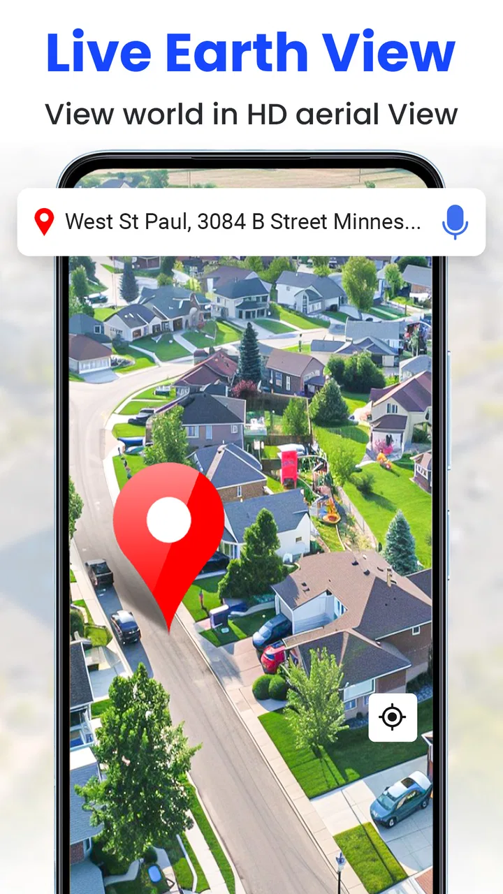
I came away from GPS Satellite Live Earth Map with a fairly clear impression: it is more useful as a visual map companion than as a complete replacement for a mature navigation service. I like the idea behind it, especially for people who want to switch between ordinary map views, satellite imagery, GPS positioning, and an earth-camera style presentation from one place. At the same time, the app asks you to understand what it is best at before relying on it for an important journey.
That distinction matters because the app sits in the Maps & Navigation category, but its appeal is not limited to turn-by-turn travel. I found it more interesting when I used it to inspect an area, understand the shape of a neighborhood, look at landmarks from above, or get a broader visual sense of a destination. For everyday driving, established navigation tools may still feel more complete. For map exploration and a quick satellite perspective, this app has a more approachable purpose.
What the satellite map experience does well
The main strength is the way the app puts a satellite-oriented view at the center of the experience. A conventional road map is excellent for street names and route planning, but an aerial view can answer different questions. I can see the relationship between buildings, open spaces, roads, coastlines, parking areas, and surrounding terrain in a way that a standard colored map often cannot show clearly.
You May Also Like

 Blood Strike: 2.5 Anniversary
Blood Strike’s Loadouts Turn Every Drop Into a Tactical Gamble
A close look at Blood Strike’s custom loadouts: how fast access to signature weapons reshapes its battle royale rhythm, rewards preparation, and narrows the gap between fights.

 Pandora - Music & Podcasts
Pandora’s Music Is Easy to Start, but Harder to Recover
Pandora’s strength is its low-effort path from a seed to a station. Its weak spot is how much confidence it asks you to place in connection, setup, and quiet recovery.

 8 Ball Pool
 Is Built on Rivalries, Rematches, and Routine
A close look at the rivalries, rematches, shared routines, and unanswered safety questions that turn a quick pool match into a persistent mobile community.

 Samsung Music
’s Quiet Strength Is Playing What You Already Own
Its reach comes less from spectacle than from dependable access to a personal library. That simplicity is both the app’s strongest retention engine and its ceiling.

 AccuWeather: Weather Radar
AccuWeather Review: A Quick, Clear Forecast for Everyday Decisions
For everyday plans, the best forecast is the one you can understand quickly. AccuWeather makes rain timing, radar, and local conditions easy to act on, with a few trade-offs.

 Hill Climb Racing
Why Hill Climb Racing Still Turns Crashes Into One More Run
A tiny car, a bumpy hill and one more upgrade: Hill Climb Racing keeps resurfacing because its simple chaos makes every near-miss feel personal.
More From Our News Desk



That makes the app handy before visiting an unfamiliar place. If I am checking a venue, a rural address, or a large property, the satellite perspective can help me form a mental picture before I arrive. I would not treat that image as a guarantee of current conditions, but it is useful for orientation. In my experience, this is where the application feels more distinctive than a basic GPS screen that only shows a moving dot and a route line.
The GPS element also gives the app a practical starting point. When I want to understand where I am in relation to nearby roads or recognizable features, opening the map around my position is quicker than manually searching from scratch. That is particularly convenient during a walk in an unfamiliar district, while visiting a large outdoor area, or when I need to explain my general location to someone else.
There is a small but important difference between knowing an address and understanding a place. The address tells me where to go; the aerial view helps me picture what I may see when I get there. I found that combination more valuable for planning than for active navigation. It can help me notice whether a destination appears close to a main road, surrounded by open land, or located inside a dense group of buildings.
The live earth camera concept adds another visual layer. I see it as an exploratory feature rather than a professional geographic tool. It encourages casual discovery and makes the app feel less like a plain directory of roads. Someone who enjoys looking at places from above, comparing urban layouts, or browsing locations for a trip may get more enjoyment from it than someone who only wants the shortest route.
One useful workflow is to use the app before leaving rather than waiting until I am already moving. I can inspect the destination, look at the surrounding area, and then decide whether the map view gives me enough context for the visit. This reduces the temptation to study a detailed screen while walking or driving. The app works best when it supports preparation and orientation, not when it becomes a distraction during travel.
Another practical use is checking the approach to a location that may be confusing on arrival. A satellite image can sometimes reveal the position of a building, a large entrance area, or a nearby open space more intuitively than a road-only view. I would still verify signs and local access once there, but the visual preview can make the first few minutes less uncertain.
The audience size suggests that the concept has broad appeal. The app has passed ten million installs, which places it well beyond a niche experiment. Its average rating is 3.1, so the overall reaction is mixed rather than overwhelmingly enthusiastic. I read that combination as a useful warning: many people are curious enough to try it, but the experience may not satisfy everyone who expects a full-featured navigation replacement.
Useful habits that make the app easier to judge
My first tip is to separate visual exploration from route dependence. Use the satellite view to understand an area, then compare the actual route information with the navigation tool you normally trust. This two-step approach lets the app contribute something meaningful without asking it to handle every part of a journey.
My second tip is to check the map at more than one zoom level. A close view may help identify the immediate surroundings, while a wider view explains how the destination connects to the rest of the area. Looking only at the closest image can create a misleading sense of context, especially around large properties or roads that curve away from the visible entrance.
A third tip is to prepare screenshots or notes before entering a place where attention will be limited. I would not recommend repeatedly interacting with a phone while driving, and even walking navigation can become awkward when the screen demands constant focus. The app is more valuable when it gives me a quick mental reference that I can remember, rather than when I stare at it continuously.
For travelers, I would also compare the visual map with the destination’s own instructions. A satellite image may show the shape of a site, but it does not automatically explain which entrance is open, where visitors should park, or whether a visible path is public. That is a subtle but important trade-off: aerial context improves understanding, while local instructions remain necessary for decisions about access.
Where the experience becomes less convincing
The biggest weakness is the gap between the promise of live navigation and the expectations created by that phrase. A person may install the app expecting the same polished guidance, traffic awareness, route refinement, and destination detail found in a long-established navigation platform. I would be cautious about making that assumption. The app’s stronger identity is visual mapping and GPS-based orientation, not necessarily an all-in-one commuting system.
That limitation becomes more important on unfamiliar roads. If I were driving through a busy city, managing several junctions, or following a time-sensitive route, I would prefer a service whose entire experience is built around dependable navigation guidance. This app can still be useful as a secondary map, but I would not make it my only source of direction for a trip where a wrong turn would cause serious trouble.
The satellite view itself also needs sensible interpretation. Aerial imagery is excellent for seeing layout, but it should not be treated as a live security camera or a guaranteed real-time picture of every change on the ground. Construction, temporary closures, parked vehicles, weather, and altered entrances can all make reality different from what the image suggests. The app’s visual appeal should not replace common sense or current local signs.
I also noticed a potential learning curve in deciding which view to use for which task. Someone who simply wants a clean route from one address to another may find the additional visual elements unnecessary. The more features an app places around the map, the more important it becomes to keep the immediate task clear. If the goal is only to reach a destination, a simpler navigation interface may feel faster and less distracting.
There is also a cost consideration, even though the app itself is free. Optional in-app purchases range from $1.99 to $7.99 per item. That does not automatically make the app poor value, but I would first spend time with the free experience and decide whether the extra options solve a problem I actually have. Paying for a feature that only makes the map look more interesting would be harder for me to justify than paying for something that improves a regular workflow.
Performance expectations should be realistic as well. Satellite imagery and map interfaces can be visually demanding, and the experience depends on the phone, the connection, and the amount of map detail being displayed. I would avoid judging the app after a single slow screen or assuming that every location will feel equally smooth. For regular use, I would test it in the places where I actually need it, including the neighborhoods and travel areas I visit most often.
A realistic everyday scenario
Imagine that I am meeting a friend at a large venue for the first time. The street address gets me close, but the property has several buildings and a broad surrounding area. Before leaving, I open the app, locate the venue, switch to the satellite perspective, and inspect the roads around it. I can get a better sense of the building’s position and the nearby layout than I would from a simple written address.
On arrival, I would use the map only as a reference and follow signs or instructions from the venue. If the entrance is not where I expected, the aerial view may help me understand the surrounding arrangement, but it cannot tell me whether a particular driveway is currently available. In this scenario, the app adds genuine value without pretending to replace local information.
A similar workflow works for a walking visit to an unfamiliar park or outdoor area. I can examine the broader shape of the place before setting out, identify nearby roads, and keep a general sense of direction. The benefit is not perfect navigation at every step; it is reducing the feeling of arriving somewhere with no visual context.
Who should install it, and who should skip it
I think the app is a good fit for curious map users, casual travelers, students, property viewers, and anyone who finds satellite imagery easier to understand than a conventional map. It may also suit people who want a free way to explore locations visually before using another service for precise travel instructions. The Everyone content rating makes it approachable for a broad audience, and the app is available at no upfront price.
It is particularly suitable if your question is, “What does this area look like from above?” rather than, “What is the fastest route with every possible travel update?” That distinction captures the app’s strongest use case. I would recommend it to a friend who enjoys geographic exploration or wants a second visual perspective on a destination.
I would skip it if I need a single navigation tool for daily commuting, complex driving routes, or high-confidence guidance in unfamiliar traffic conditions. In those situations, the usual alternatives may be better because they are designed around route instructions first. I would also skip it if I dislike experimenting with map views and only want a minimal screen that gets me from one address to another.
The developer, Sona Apps Studio, has positioned the app around a broad mixture of GPS, satellite mapping, directions, and earth imagery. That combination is appealing, but it also means users should decide which part they value most. If the satellite and exploration side is the reason for installing it, the app makes more sense. If every advertised element must perform like a specialized standalone service, expectations may become difficult to meet.
Device support, maturity, and day-to-day value
The app was released on July 15, 2020, and its current version is 4.1.1. It supports devices running Android 8.0 or later, so people using older phones may need to check compatibility before planning around it. For a current Android user, the more important question is not simply whether it installs, but whether the interface feels comfortable on the particular screen and hardware being used.
Its free entry point makes testing straightforward. I would install it, search for several familiar places, compare the satellite perspective with what I know on the ground, and try the GPS view during a short, low-risk outing. That quick personal test tells me more than a store summary because map usefulness depends heavily on my locations and habits.
I would also keep the app in a supporting role until I had tested it enough to trust its behavior. For instance, I might use it to preview a destination while keeping my regular navigation option available for the actual drive. This is not a criticism of the concept; it is a sensible way to use any mapping app whose main advantage is visual context rather than proven daily routing.
One of the app’s less obvious strengths is that it can change how I prepare for a destination. Standard navigation often starts when I am already committed to a route. A satellite map encourages me to think about the place itself: its shape, its surroundings, and the relationship between roads and buildings. That can be valuable for planning visits, explaining locations to others, or deciding whether a destination looks easy to approach.
The corresponding trade-off is that visual information can create false confidence. Seeing a road or open area from above does not prove that I can use it, enter from a certain side, or reach it without obstacles. I would treat the map as a planning aid, not as permission or a current access report.
My final view after weighing the trade-offs
GPS Satellite Live Earth Map is worth trying if you want a free, visually oriented map app that combines GPS positioning with satellite-style exploration. Its strongest contribution is helping me understand places from above and prepare for visits with more context than a basic road map provides. The earth-camera angle gives it some personality, while the broad install base shows that the idea has reached many Android users.
My recommendation comes with a clear boundary: I would not make it my sole navigation solution until I had tested it thoroughly for my own routes. The mixed average rating, the possibility of paid extras, and the difference between visual mapping and full travel guidance all point toward a supporting role. For serious daily navigation, a more specialized alternative may be the safer choice.
For the right person, though, that is not a deal-breaker. I would recommend it to a friend who wants to inspect destinations, explore satellite views, and get a broader sense of an area before arriving. Use it for visual orientation first, and treat precise route decisions as a separate responsibility. With that expectation, the app feels useful and enjoyable; without it, the promise of an all-purpose live map may feel larger than the everyday experience.
FAQs for GPS Satellite Live Earth Map
01What features does GPS Satellite Live Earth Map offer?
GPS Satellite Live Earth Map provides real-time satellite imagery, detailed maps, and navigation assistance. Users can explore geographic locations, get driving directions, and view live traffic updates. Additionally, the app offers street view and 3D visualization, making it ideal for both travel planning and educational purposes.
02Is GPS Satellite Live Earth Map free to use?
Yes, the basic version of GPS Satellite Live Earth Map is free to download and use. However, it may offer in-app purchases for premium features such as ad removal, enhanced map details, or offline access. Check the app store listing for specific details on pricing and subscription options.
03How accurate is the GPS and navigation on this app?
The app utilizes high-precision GPS technology, providing users with accurate navigation and real-time location updates. While it generally offers reliable service, factors such as signal strength, geographic location, and device compatibility can affect accuracy. It's advisable to keep your device updated for optimal performance.
04Can I use GPS Satellite Live Earth Map offline?
The app primarily functions online to deliver real-time data. However, some features might be available offline if you download maps in advance. This can be particularly useful in areas with limited connectivity. Check the app settings to see if offline maps are supported and how to download them.
05Is GPS Satellite Live Earth Map compatible with all devices?
GPS Satellite Live Earth Map is designed for both Android and iOS platforms. Compatibility may vary based on the device's operating system version. Ensure your device meets the minimum system requirements by checking the app store listing before downloading. Regular updates from the app developer help maintain compatibility with newer devices.
Pros
- Real-time location tracking is highly accurate.
- User-friendly interface for easy navigation.
- Offline maps available for remote areas.
- Comprehensive global satellite imagery.
- Frequent updates with improved features.
Cons
- Consumes significant battery power quickly.
- Ads can be intrusive during usage.
- Requires constant internet for live updates.
- Limited customization options for maps.
- Occasional lag in loading satellite images.

GPS Satellite Live Earth Map
Gallery